Pakistan serves as a crucial link between the West and Central Asia, the Muslim world, and specially with the USA and China due to its geostrategic importance. Pakistan is one of those few countries in the world whose geographical and strategic position is of immense importance.
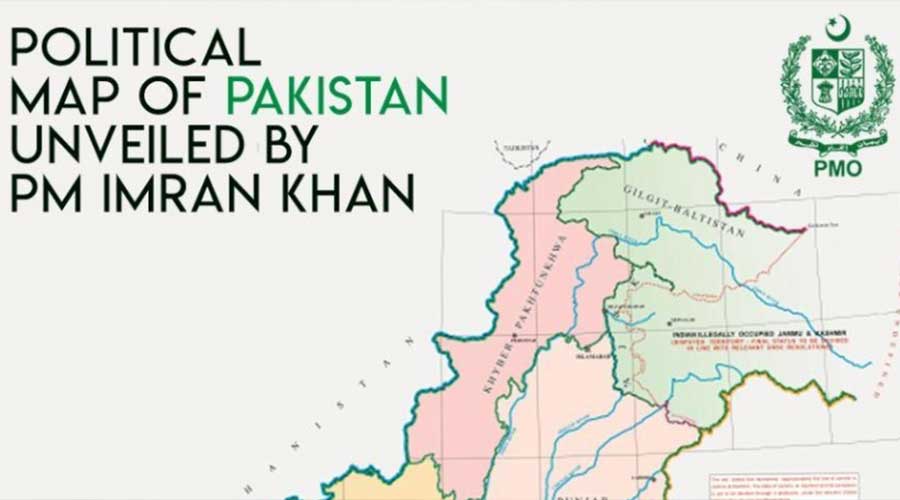
Pakistan is a land of plains, mountain ranges, deserts and coastal belt. The country shares its Eastern Border called ‘Radcliffe Line’ with India. On its Northern side, it has Sino-Pak Border. Its Western fronts include the boundaries of ‘Durand Line’ with Afghanistan and ‘Gold Smith Line’ with Iran. The Arabian Sea has limited the South of the country. With the total area of 9,96096 km square, Pakistan emerges to be one of the most significant geographical patches of Asia.
Pakistan is situated in the Asia continent between 23.300 and 36.450 latitudes (north) and 610 and 75.540 longitudes (east). India is situated on Pakistan’s eastern border, China is situated in the northeast, and Afghanistan is situated in the northwest.
In the north, only a narrow belt of about 22 km in Afghanistan separates Pakistan from Tajikistan which is known as the Wakhan Corridor. In the west of Pakistan, there is Iran, and, in the south, there is a big Arabian sea.
China is an emerging economic power of the world and for selling Chinese products in western countries; China had the only route of Hong Kong. Whereas, through Gwadar port, China has to cover the half distance for trade.
Feeling the geographical importance of Pakistan, China has started one of the biggest project called China Pakistan Economic Corridor (CPEC). This project is also called One Belt One Road (OBOR) Belt Road Initiative (BRI) or Silk Road Economic Belt and it is also called 21st century maritime Silk Road. It is a trillion-dollar project. Pakistan’s importance signifies from this fact that so far 60 countries have become its part directly or indirectly and still more countries are willing to join this mega project.
Read More: The 5 Important Rivers in Pakistan – About Pakistan
Pakistan and China jointly have constructed a long road known as Karakoram Highway which connects both countries and is known as the 8th wonder of the world. This road is actually a trade link between 3 billion people of the region with the rest of the world. Gwadar port which is perhaps the deepest port in the world is equally highly helpful for this trade. Pakistan has now 3 seaports from where international trading activities take place; one is Karachi, second is port Qasim and third is Gwadar.
Afghanistan has no sea and it always depends on Pakistan for international trades. Central Asian states and Iran also feel the geographical importance of Pakistan and therefore, the project of the gas pipeline has been started between Pakistan and Central Asian states. There is also a project of gas pipeline origination from Iran which links Pakistan and India.
Kashmir is the bone of contention between India and Pakistan and now China and India too. If it is resolved, then the whole region will elevate, and Pakistan will meet its true potential in accordance with its significant geographical and strategic positioning. It is advisable for both the countries to abolish the idea of old enmity and start spending billions of rupees on the welfare of their people through mutual trade instead of spending big amount on the purchase of weapons.


